| Date: April 21-22, 2012 | Sponsor: DDRC | |
| River: South Llano | Trip Leader: Sam Sloan | |
| Reach: US Highway 377 to South Llano River State Park | Phone: 214-957-9374 | |
| Difficulty: Class II (some small ledge drops) * (See scale below) | E-mail: ssloanmail-h2o@yahoo.com | |
| Rendezvous: South Llano River State Park, 9:00 AM Saturday | ||
| Campground: South Llano River State Park |
| Trip Description:
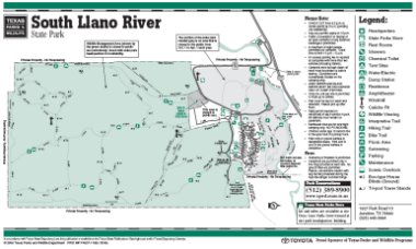
The park is located 275 miles southwest of Dallas near Junction, Texas. The scenery varies from tall cliffs to flats with over hanging pecan trees. This is a beautiful area with abundant deer and other wildlife. We will be puttng in at the US Highway 377 crossing on Saturday, and then floating down to the park (11.2 miles.) Saturday nite we will eat dinner at one of the local restaurants in Junction.
We will do a 5 mile stretch (from the state park to town) on Sunday, and then will eat lunch after the trip before returning home. I will reserve one campsite, which I will share. You are allowed up to 8 people per campsite. All campsites have water, electricity, and are $17.00 per night. People reserving a campsite for themselves or their group should try and get campsite numbers 21 thru 26, or at least close, when they arrive (that's where we were last year.) If you want to reserve an additional campsite the TPWD reservation number is (512) 389-8900, or go to the TPWD South Llano River State Park website. For a complete decription of this reach of the South Llano River please visit Southwest Paddler. Please contact Sam Sloan if you are thinking of coming so I can expect you and notify you of any changes. Gear Requirements: Boats made of tough plastic are OK - NO fiberglass canoes. It may be bumpy in places. Bring PFD's, a whistle and throwbag for each person. April should be mild, but could be cool at night. Bring sun protection - a hat and sun block - and light rain gear just in case. Also bring everything you may want for camping - tent, sleeping bag, chair, etc. Water is supplied at the park. Meals: Bring all your own meals, utensils, plate, cup, etc. We will have lunch on the river Saturday, so bring a small cooler or bag for it, but PLEASE - NO GLASS OR FOAM POLYSTYRENE STYROFOAM CONTAINERS! We will eat in Junction at a restuarant on Saturday night. Back-up Plans: There is no backup plan for this trip. If, for any reason, the trip on the South Llano River cannot be made, then it will be cancelled. Driving Directions: This reach of the South Llano River is located in Kimble County at 1927 Park Road 73, Junction, Texas 76849-9502 (Phone: 325-446-3994) near . From Dallas: Go south on US Highway 67 through Glen Rose and beyond Chalk Mountain to the SH 220 cutoff (veer LEFT onto SH 220) and go south into Hico; |
 [ LARGER IMAGE ] |
| * International Scale of River Difficulty
Class I: Easy. Fast moving water with riffles and small waves. Few obstructions, all obvious and easily missed with little training. Risk to swimmers is slight, self-rescue is easy.
Class II: Novice. Straightforward rapids with wide, clear channels which are evident without scouting. Occasional maneuvering may be required, but rocks and medium sized waves are easily missed by trained paddlers. Swimmers are seldom injured and group assistance, while helpful, is seldom needed. Class III: Intermediate. Rapids with moderate, irregular waves which may be difficult to avoid and which can swamp an open canoe. Complex maneuvers in fast current and good boat control in tight passages or around ledges are often required; large waves or strainers may be present but are easily avoided. Strong eddies and powerful current effects can be found, particularly on large-volume rivers. Scouting is advisable for inexperienced parties. Injuries while swimming are rare; self-rescue is usually easy but group assistance may be required to avoid long swims. Class IV: Advanced. Intense, powerful but predictable rapids requiring precise boat handling in turbulent water. Depending on the character of the river, it may feature large, unavoidable waves and holes or constricted passages demanding fast maneuvers under pressure. A fast, reliable eddy turn may be needed to initiate maneuvers, scout rapids, or rest. Rapids may require "must" moves above dangerous hazards. Scouting is necessary the first time down. Risk of injury to swimmers is moderate to high, and water conditions may make self-rescue difficult. Group assistance for rescue is often essential but requires practiced skills. A strong eskimo roll is highly recommended. Class V: Expert. Extremely long, obstructed, or very violent rapids which expose a paddler to above average endangerment. Drops may contain large, unavoidable waves and holes or steep, congested chutes with complex, demanding routes. Rapids may continue for long distances between pools, demanding a high level of fitness. What eddies exist may be small, turbulent, or difficult to reach. At the high end of the scale, several of these factors may be combined. Scouting is mandatory but often difficult. Swims are dangerous, and rescue is difficult even for experts. A very reliable eskimo roll, proper equipment, extensive experience, and practiced rescue skills are essential for survival. Class VI: Extreme. One grade more difficult than Class V. These runs often exemplify the extremes of difficulty, unpredictability and danger. The consequences of errors are very severe and rescue may be impossible. For teams of experts only, at favorable water levels, after close personal inspection and taking all precautions. This class does not represent drops thought to be unrunnable, but may include rapids which are only occasionally run. |
 Copyright © 1996-2010, Dallas Downriver Club. All rights reserved. CobraGraphics is the trademark of Marc W. McCord dba CobraGraphics. The textual, graphic, audio, and audio/visual material in this site is protected by United States copyright law and international treaties. You may not copy, distribute, or use these materials except for your personal, non-commercial use. Any trademarks are the property of their respective owners. All original photographic images are the exclusive property of Dallas Downriver Club or other designated photographers and may not be copied, duplicated, reproduced, distributed or used in any manner without prior written permission of the copyright owner under penalty of US and International laws and treaties. |