
Neches River near Diboll, Tx

| Date: March 14-16, 2014 | Sponsor: DDRC |
| River: Neches | Trip Leader: Sam Sloan |
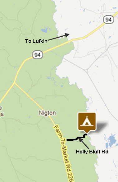
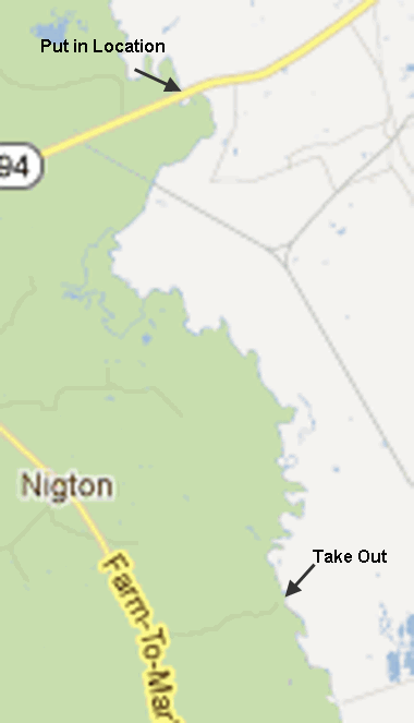
| Reach: Hwy 94 to Holly Bluff Campground (11.6 miles) | Phone: 214-957-9374 |
| Difficulty: Flatwater * (See scale below) | E-mail: Sam Sloan |
| Rendezvous: 9am @ Hwy 94 bridge | Required Skills: Basic flatwater paddling and base camping experience |
| Campground: Holly Bluff Campground near Diboll, TX | Confirmation Deadline: March 1st, 2014 |
| Trip Description:
This trip will start Friday evening as we base camp at Holly Bluff Campground. The campground is on the Neches river in the Alabama Wildlife Mgt. Area. Be sure and bring everything you need with you as this is a primitive campground with no water or facilities. I will bring a potty and privacy tent. There are no camping fees. This is in a heavily forested region near Davy Crockett National Forest. It is a beautiful remote area with abundant wildlife. The river here winds thru forested hills, and is a tea color from the tannic acid in tree leaves. Saturday morning we will shuttle up to the put in at Hwy. 94. It is about 11.5 river miles to the campground.We will be traveling light, as our gear will be at base camp. Be sure to bring plenty of water and a picnic lunch. Saturday night we will have a pot luck dinner and relax at the campground. Sunday we will run a shuttle down to the Hwy. 59 bridge – and paddle that section which is about another 10 miles. Another option for everyone is try a little fishing, hiking, or just take their time and socialize, before heading home. Please contact Sam Sloan 214-957-9374, if you plan to come, so I can notify you of any change in plans.
Gear Requirements: Bring tent
sleeping bag, food, and water etc. This is a primitive campsite! I will bring
a potty/tent if needed. Just about any canoe or kayak will do - the only hazards are downed trees Meals: Pot luck Saturday night and a small cooler for your lunch. Back-up Plans: If weather is not suitable for a trip, then it will be cancelled with no reschedule date. Driving Directions: Directions
from Dallas: Take I-45
south to Centerville. Go east on Hwy.7 to Crockett then south again on
Hwy. 287 to Groveton. Then just pass Groveton take a left on FM 2262 .
Follow 2262 NE till it makes a left turn. then follow it NNW up to Holly
Bluff road otherwise known as 510A and take a right. Follow this about a
mile to Holly Bluff campground. You can also take 175 to Jacksonville. Then 69 to Lufkin, Then south on 94 to FM 2262. Turn left on 2262 go about 5 mi. to Holly bluff road 510A .Turn left on Holly Bluff and follow to campground.
|
  |
| * International Scale of River Difficulty
Class I: Easy. Fast moving water with riffles and small waves. Few obstructions, all obvious and easily missed with little training. Risk to swimmers is slight, self-rescue is easy.
Class II: Novice. Straightforward rapids with wide, clear channels which are evident without scouting. Occasional maneuvering may be required, but rocks and medium sized waves are easily missed by trained paddlers. Swimmers are seldom injured and group assistance, while helpful, is seldom needed. Class III: Intermediate. Rapids with moderate, irregular waves which may be difficult to avoid and which can swamp an open canoe. Complex maneuvers in fast current and good boat control in tight passages or around ledges are often required; large waves or strainers may be present but are easily avoided. Strong eddies and powerful current effects can be found, particularly on large-volume rivers. Scouting is advisable for inexperienced parties. Injuries while swimming are rare; self-rescue is usually easy but group assistance may be required to avoid long swims. Class IV: Advanced. Intense, powerful but predictable rapids requiring precise boat handling in turbulent water. Depending on the character of the river, it may feature large, unavoidable waves and holes or constricted passages demanding fast maneuvers under pressure. A fast, reliable eddy turn may be needed to initiate maneuvers, scout rapids, or rest. Rapids may require "must" moves above dangerous hazards. Scouting is necessary the first time down. Risk of injury to swimmers is moderate to high, and water conditions may make self-rescue difficult. Group assistance for rescue is often essential but requires practiced skills. A strong eskimo roll is highly recommended. Class V: Expert. Extremely long, obstructed, or very violent rapids which expose a paddler to above average endangerment. Drops may contain large, unavoidable waves and holes or steep, congested chutes with complex, demanding routes. Rapids may continue for long distances between pools, demanding a high level of fitness. What eddies exist may be small, turbulent, or difficult to reach. At the high end of the scale, several of these factors may be combined. Scouting is mandatory but often difficult. Swims are dangerous, and rescue is difficult even for experts. A very reliable eskimo roll, proper equipment, extensive experience, and practiced rescue skills are essential for survival. Class VI: Extreme. One grade more difficult than Class V. These runs often exemplify the extremes of difficulty, unpredictability and danger. The consequences of errors are very severe and rescue may be impossible. For teams of experts only, at favorable water levels, after close personal inspection and taking all precautions. This class does not represent drops thought to be unrunnable, but may include rapids which are only occasionally run. |
|
Copyright © 1996-2011, Dallas Downriver Club. All rights reserved.
You may not copy, distribute, or use these materials except for your personal, non-commercial use. Any trademarks are the property of their respective owners. All original photographic images are the exclusive property of Dallas Downriver Club or other designated photographers and may not be copied, duplicated, reproduced, distributed or used in any manner without prior written permission of the copyright owner under penalty of US and International laws and treaties. |